


June 01, 2014
Hema - Old Telegraph Track North
29.0 kmHEMA CAPE YORK ATLAS & GUIDE - TRACK #11
This track requires low range and high ground clearance in addition to appropriate traction aids. Driving from the turnoff to Fruit Bat Falls, we took the Mistake Creek turnoff to the Northern Bypass Road to avoid a swollen Nolan's Brook.
This is Track #11 from our Cape York Atlas & Guide, which you can purchase online here: http://bit.ly/capeguide
June 01, 2014
Hema - Bramwell to Bamaga
249.3 kmHEMA CAPE YORK - BRAMWELL TO BAMAGA
Driving from Bramwell Roadhouse to Bamaga along Bamaga Road before going up to Seisia.
For more information on this region refer to our Cape York Atlas & Guide, which you can buy online here: http://bit.ly/capeguide
May 30, 2014
Hema - Peninsula Developmental Road to Weipa
220.8 kmHEMA CAPE YORK - PDR TO WEIPA
Driving from the intersection of the Peninsula Developmental Road and Telegraph Road to Weipa then to Moreton Telegraph Station.
We took a detour to Merluna before continuing on to Weipa, with the track changing often but not throwing up anything too difficult.
For more information on this trip and region refer to Hema's Cape York Atlas & Guide, which you can purchase online here: http://bit.ly/capeguide
May 29, 2014
Hema - Lakeland to Bramwell
598.2 kmHEMA CAPE YORK - LAKELAND TO BRAMWELL
Driving from Lakeland to Bramwell Junction Roadhouse along the Peninsula Developmental Road and Telegraph Road.
For more information on this region refer to Hema's Cape York Atlas & Guide, which you can purchase online here: http://bit.ly/capeguide
May 27, 2014
Hema - Bloomfield Track
168.6 kmHEMA CAPE YORK - MOSSMAN TO COOKTOWN
The Bloomfield Track is relatively simple to negotiate in comparison to many of Cape York's tracks, though after heavy rain the track was interesting and landslips were not uncommon.
For more information on the Bloomfield Track, consult Hema's Cape York Atlas & Guide, which you can buy online here: http://bit.ly/capeguide
February 07, 2014
Hema - North Stradbroke Island
56.2 kmHEMA 4WD + CAMPING ESCAPES SE QLD - TRACK #2
This is a half to full day trip which requires high ground clearance and low tyre pressure (16psi recommended), especially in churned and soft sand.
North Stradbroke Island is a holidayer's dream, with pristine beach camping, good off-roading opportunities and closeness to facilities and supplies at Amity, Point Lookout and Dunwich.
This particular track is Track #2 in Hema's 4WD + Camping Escapes - South East Queensland Atlas & Guide, which contains the best 20 4WD trips and 300 camping areas near Brisbane.
Buy your copy online here: http://bit.ly/seqld4wd
Watch the time-lapse video of this trip: http://youtu.be/a2pt8L_c81E
February 01, 2014
Hema - Bribie Island
24.4 kmHEMA 4WD + CAMPING ESCAPES SE QLD - TRACK #1
This half-day or overnight trip is an easy beach run when the tide is out, and a perfect testing ground for less experienced four-wheel drivers.
There's plenty to see and do on Bribie Island such as camping in the beautiful Ocean Beach Camping Area, driving on compacted sand while negotiating occasional freshwater creeks, and even seeing some WWII relics to experience Australia's history in the war.
This is Track #1 in 4WD + Camping Escapes - South East Queensland, a Hema atlas & guide featuring the Top 20 4WD Trips and 300 best camping areas to discover near Brisbane.
Buy your copy online today: http://bit.ly/seqld4wd
January 31, 2014
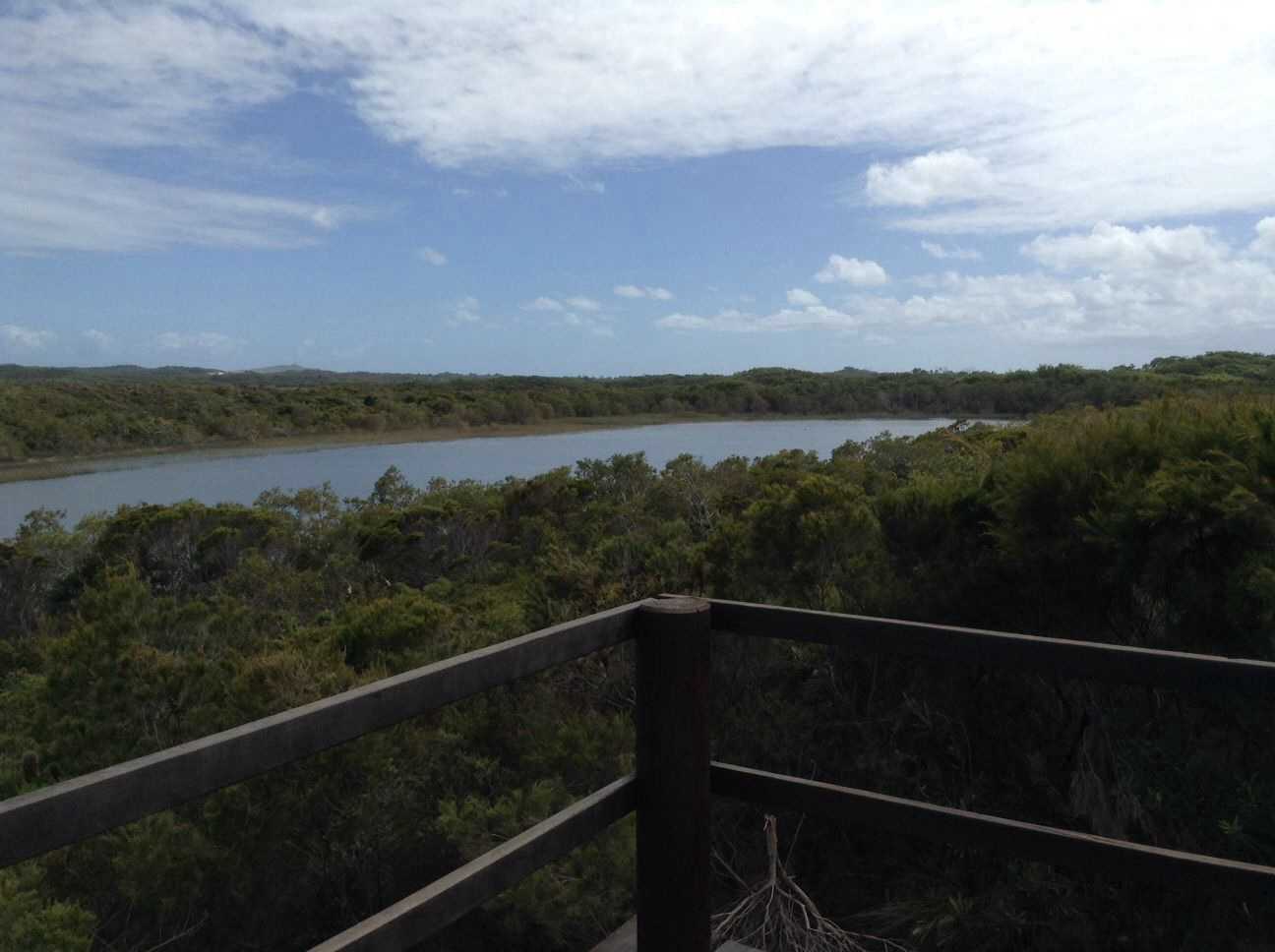
Hema - Moreton Island North
51.9 kmHEMA 4WD + CAMPING ESCAPES SE QLD - TRACK #3
This full day or overnight trip is a scenic loop of Moreton's north half, requiring high ground clearance and low tyre pressure (especially when moving from the beach inland).
Visit the historic Cape Moreton lighthouse, walk to Blue Lagoon or to the Mt Tempest lookout, and choose between no less than 5 designated camping areas and 3 bush camping zones.
This is Track #3 in Hema's 4WD + Camping Escapes - South East Queensland atlas & guide, which offers complete coverage of the Top 20 4WD Trips and 300 best camping areas near Brisbane.
Buy your copy online here: http://bit.ly/seqld4wd
Watch the time lapse video of this trip: http://youtu.be/jZmYRlGiJOc
My Photo - 29/01/2014 9:44:39am
January 29, 2014
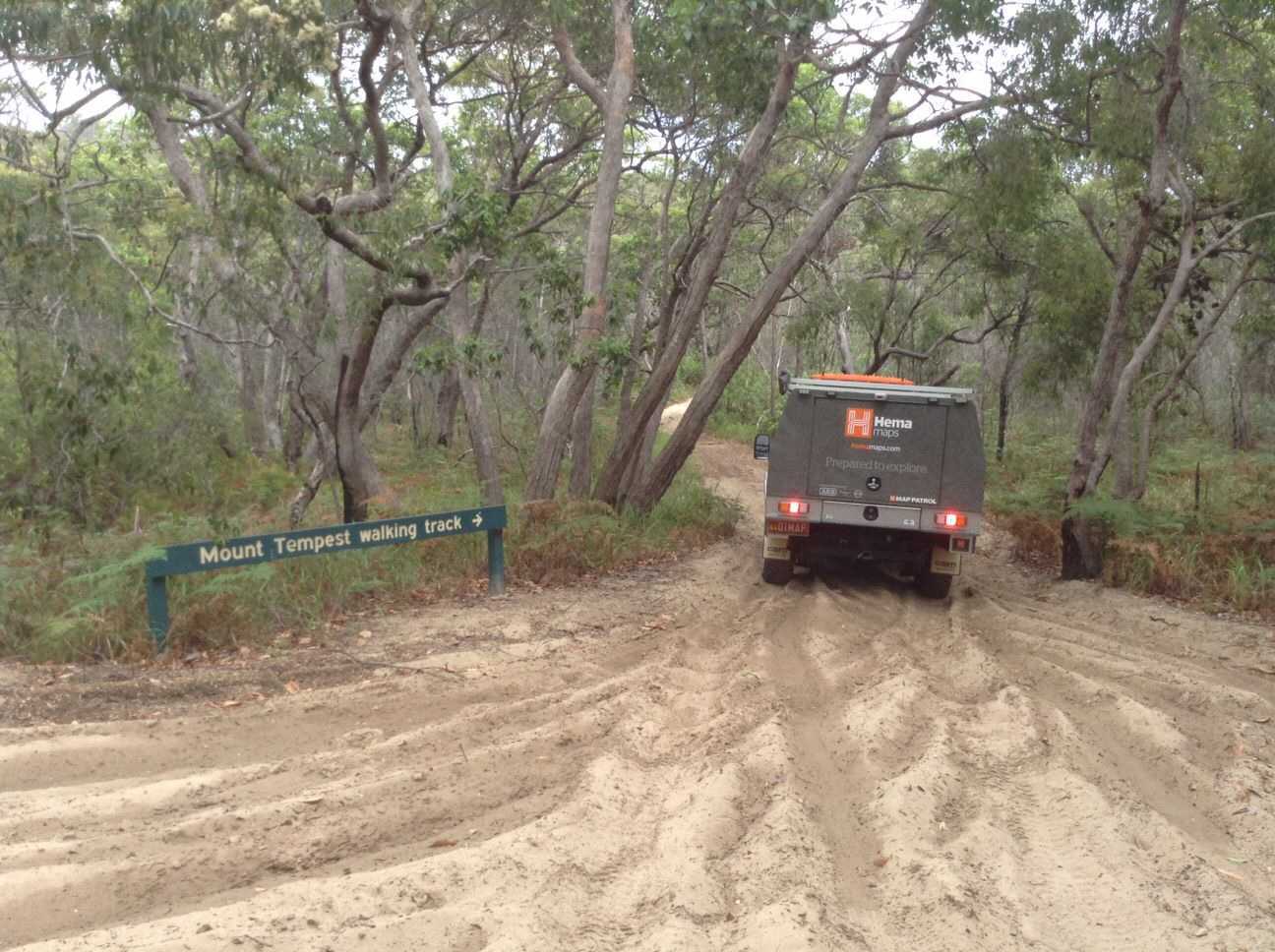
Hema - Moreton Island South
36.8 kmHema - Moreton Island South
HEMA 4WD + CAMPING ESCAPES SE QLD - TRACK #4
This half-day trip can be started from Kooringal or Tangalooma, and requires high ground clearance and low tyre pressure (especially when moving from the beach inland).
Taking in the excellent Western Beach and Middle Road, there are opportunities along this track to see the Rous Battery WWII fort, to take in the views from the top of Mount Tempest and to visit the Wrecks.
This track is Track #4 in Hema's 4WD + Camping Escapes - South East Queensland atlas & guide, which features the Top 20 4WD Trips and 300 best camping areas around the Brisbane region.
Buy your copy online today: http://bit.ly/seqld4wd
My Photo - 28/01/2014 10:34:14am
January 24, 2014
Hema - Cooloola Recreation Area
63.6 kmHEMA 4WD + CAMPING ESCAPES SE QLD - TRACK #10
This is a reasonably smooth beach run with some slightly difficult cuttings when the sand is very dry. Ensure you time your beach run so you are driving in the 2 hours either side of low tide.
Watch the time lapse video of this track here http://www.youtube.com/watch?v=ip8gvIJOfsE
This track is Track #10 in Hema's 4WD + Camping Escapes - South East Queensland atlas & guide, which features the Top 20 4WD Trips and 300 best camping areas near Brisbane.
Buy your copy online here: http://bit.ly/seqld4wd
Watch a time lapse video of this track: http://youtu.be/ip8gvIJOfsE
There are no favorites to display